Geography
Location
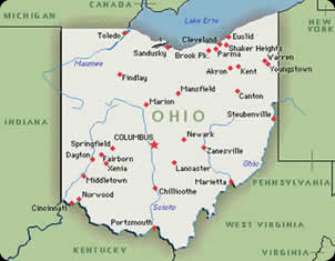
Ohio's largest cities are: Akron, Cincinnati, Cleveland, Columbus, Dayton, Toledo, and Youngstown.
Ohio is bordered by the following states, countries, and landforms:
To the north, Michigan (state), Lake Erie (landform), and Canada (country). To the east, Pennsylvania (state), West Virginia (state), and the Ohio River (landform). To the south, Kentucky (state). And to the west, Indiana (state). Canada's border with Ohio is under water in Lake Erie.