News

Now a Category 4 Storm, Slow-Moving Dorian Batters Bahamas, Tracks Toward U.S.
By: Brakkton Booker | NPR
Posted on:
Updated at 11:41 p.m. EST
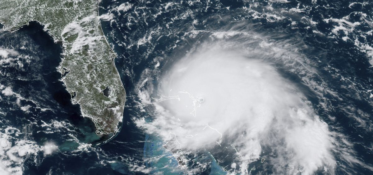
Slow-moving Hurricane Dorian continues to produce “catastrophic hurricane conditions” as it pummels Grand Bahama Island. It has now been downgraded to a Category 4 hurricane, according to the latest National Hurricane Center advisory.
That gives little comfort to those enduring the powerful storm, given it is crawling west at 1 mph, a pace slower than most people can walk.
Dorian’s maximum sustained winds were near 165 miles per hour in the NHC’s previous advisory, but it now says the winds have dropped to 155 miles per hour.
When Dorian made landfall Sunday on the Abaco Islands it was described as “the strongest hurricane in modern records” to hit the archipelago. Even though the storm has weakened some, officials warn residents not venture outside because “winds will suddenly increase after the eye passes.”
The NHC urges Eastern Seaboard residents from Florida’s east coast all the way up to North Carolina’s Outer Banks to monitor the storm closely.
Speaking from an emergency call center in the city of Freeport, Don Cornish, the disaster manager for Grand Bahama said the storm sounds “like a freight train is passing,” adding that there is flying debris and intensifying rain.
“We’re getting a lot of frantic people calling in about flooding issues, and they’re very concerned because of the storm surge, how it’s affecting their homes,” Cornish told Morning Edition host Rachel Martin on Monday.
Cornish says the emergency center has received reports about people trying to get out in these conditions because of the level of water in their homes.
He says he expects this hurricane will “disrupt very much the quality of life” for many on the island.
Although the NHC is forecasting “gradual weakening,” Dorian is expected to remain a powerful hurricane for the next couple of days.
NPR’s Greg Allen, based in Miami, says determining where the storm will go from here is difficult.
“The track is very challenging on this because it’s moving so slowly at this point,” Allen said Monday on Morning Edition. “We know that at some point it’s going to turn and move north, but right now it’s still over the Bahamas. It’s moved on from Abaco where it spent the entire day yesterday.”
Hurricane conditions are expected on the east coast of Florida by late Monday or early Tuesday, along with what the National Hurricane Center is calling “life-threatening storm surge” that will create tides as high as 18 feet to 23 feet above normal levels. That will cause “normally dry areas” near the coast to become inundated by rising waters moving from the shoreline inward.
Dorian is expected to move in a west to west-northwestward direction in the next 24 hours or so before moving north towards the continental United States.
The storm’s center currently is not forecast move over land again, but the Atlantic coastline from Florida to North Carolina could be impacted before the storm moves farther offshore.
President Trump approved an emergency declarations for Georgia and South Carolina ordering federal assistance for state, tribal and local responses “due to the emergency conditions” from Dorian, according to White House statements released on Monday.
The White House statement comes hours before Georgia Gov. Brian Kemp, a Republican, said a mandatory evacuation was to go into effect for several counties east of the Interstate 95.
The mandatory evacuations are in effect for Bryan, Camden, Chatham, Glynn, Liberty, and McIntosh counties were to begin Monday at noon.
In a tweet, Gov. Kemp urged residents to “stay vigilant and be safe.”
At a mid-morning briefing Monday, Florida’s Republican Gov. Ron DeSantis said he had been in touch with the President. He said the President is “fully engaged” and promised to provide resources the state needs to weather Dorian.
DeSantis says the storm has “basically stalled out” a little more than 100 miles east of Florida city of West Palm Beach, a situation he admits is “frustrating to many Floridians.
“This has been frustrating, I know, for a lot of people because this seems like we’ve been talking about this for a long time,” DeSantis said. “Bet we are in a situation where the storm is stalling very close to our coast. It is going to make a movement. And the movement that it makes is going to have a lot of impact on Floridians.”
He said more than 17,000 crew members with Florida Power and Light are on standby throughout the state to restore power should the storm knock it out.
A hurricane watch is in effect for Florida from north of Deerfield Beach to the Jupiter Inlet. The watch extends from Flager and Voluisa County line to the Altamaha Sound in Georgia.
The National Hurricane Center also issued a storm surge watch is in effect for North Deerfield Beach to the south of Latana as well as to the north to the Savannah River.
9(MDI4ODU1ODA1MDE0ODA3MTMyMDY2MTJiNQ000))

